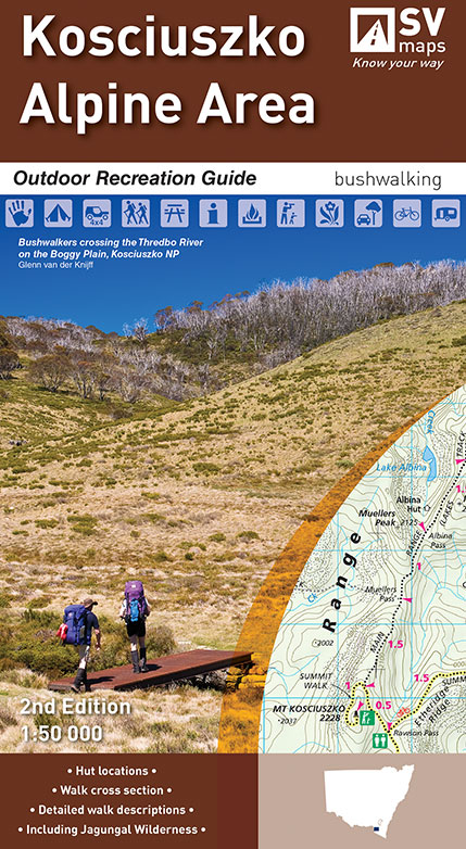
Kosciuszko Alpine Area Map Spatial Vision
$19.95 – $34.95
Description:
Now Print on Demand 2 Sided Map and Text
SEE BELOW for single sided print also, a Poster of the area
The Kosciuszko Alpine Area Outdoor Recreation Guide has detailed walk descriptions of some of the most popular walks in the area, including the Main Range Track, the Kosciuszko Walk and walks in the Jagungal Wilderness. Detailed route notes indicate walk times, distance and level of difficulty of each walk.
Special Features include major walks:
Mt Jagungal Walk, Blue Lake to Carruthers Peak, Crackenback to Thredbo, Main Range Track, Mt Kosciuszko Summitt Walk, North Rams Head.The Australian Alpine Walking Track Cascade Hut to Thredbo, Thredbo to Charlottes Pass, Charlottes Pass to Guthega Power Sation, Guthaga Power Station to Valentine Hut, Valentine Hut to Tumut River, Tumut Hut to Mackays Hut.
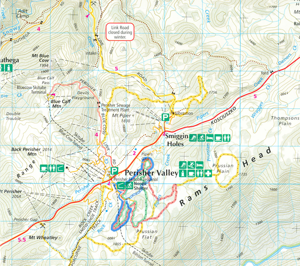
Also Jindabyne, Lake Jindabyne, Chimneys Ridge inset, Perisher Valley, Charlotte Pass, Thredbo, Tom Groggin Rest Area, Khancoban, Albina Hut Ruins, Behrs Flat Camp Ground, Boltons Hut site only, Botherum Hut, Bullocks Hut, Burrungubugge Shelter site, Cascade Hut, Cootapatamba Hut, Davies Hut, Disappointment Hut Spur, Doctor Forbes Hut, Doctors Hut, Dogmans Hut, Geehi Dam Camp Ground, Geehi Hut, Grass Flat Camp Ground, Geehi Flats Rest Area, Grey Hill Cafe Hut ruins, Grey Mare Hut, Horse Camp Hut, Island Bend Camp Ground, Keebles Hut, Kidmans Hut, Kosciuszko Tourist Park, Leatherbarrel Creek Camping Ground, Major Clews Hut, Mawsons Hut, Murray Gates Camp Ground, Ngarigo Camp Ground, Nordic Shelter, Opera House Hut, Orange Diane Hut Ruins, Schlink Hilton, Seamans Hut, Teddys Hut, Thredbo Diggings Camp Ground, Tin Hut, Tom Groggin Camp Ground, Valentine Hut, White River Hut, YHA Hut (the old hGeehi Hut)
- Colour topographic map at 1:50,000 scale
- Overnight hiking routes and campsites
- Selected walking track cross sections indicating slope and difficulty
- Major recreational facilities, huts, parks and forests
- GPS co-ordinates of campsites and huts
- Historical information and photographs
SCALE: 1:50,000
COVERAGE: Khancoban, Jindabyne, Thredbo, Perisher Valley
IDEAL FOR: Bushwalking, Cross-country skiing, rock climbing, mountain biking and car touring
EDITION: 2
SIZE (folded):135mm wide and 250mm high
SIZE (unfolded): 1000mm wide by 810mm high
ISBN : 9780995427600
You may also like…
-
Namadgi ACT South Activities Map Rooftop
$12.95 – $25.00Select options This product has multiple variants. The options may be chosen on the product page -
Bush Huts Kosciusko National Park Rooftop
-
Perisher Valley 1-25,000 NSW Topographic Map
$16.95 – $29.95Select options This product has multiple variants. The options may be chosen on the product page