

Kinglake North 1-25,000 Vicmap Topographic Map
$14.00 – $26.00
Description:
ONLY A SECTION OF THE KINGLAKE NATIONAL PARK, SEE BLEOW FOR THE 2 MAP SET THAT COVERS ALL THE NATIONAL PARK AT 1-25,000
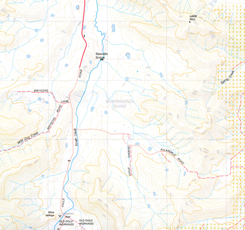
Kinglake North 1-25,000 Vicmap Topographical map NOW PRINT ON DEMAND is used for Walking, 4WD, Fishing, Camping, Motorcycle, both On and Off Road, Gold Prospecting and for those simply going for a family weekend drive.
This is a new series of 1-25,000 scale maps, all sections of Victoria are covered by these maps.
Topographical maps show not only Contours of the Terrain but Walking Tracks, Sealed and Unsealed Roads, Rivers, Creeks, Lakes, Historical Points of Interest, Old Mine mbtg Sites and National and State Park areas.
Now available printed on Waterproof Plastic Paper Folded
Main Locations on this map
Covers the old edition maps Wandong and Reedy Creek
Heathcote Junction, Waterford Park, Walls Crossing, Bald Hills, Reedy Creek Bridge, Saint Anne Hill, Clonbinane, Sunday Creek Reservoir, Murchison Spur, Mt Disappointment State Forest, Bassetts Bridge, Tunnel Hill, Strath Creek Falls, Margaret Falls Lower and Middle, Seldom Seen, Part of Kinglake National Park, Digger Gully
 2 MAP SET COVERING ALL THE NATIONAL PARK
You may also like…
-
Glenburn 1-50,000 Vicmap
$12.00 – $24.00Select options This product has multiple variants. The options may be chosen on the product page -
Kinglake Special North and South 1-25,000 Vicmap Topographic Map Set
$26.00 – $50.00Select options This product has multiple variants. The options may be chosen on the product page -
Kinglake South 1-25,000 Vicmap Topographic Map
$14.00 – $26.00Select options This product has multiple variants. The options may be chosen on the product page