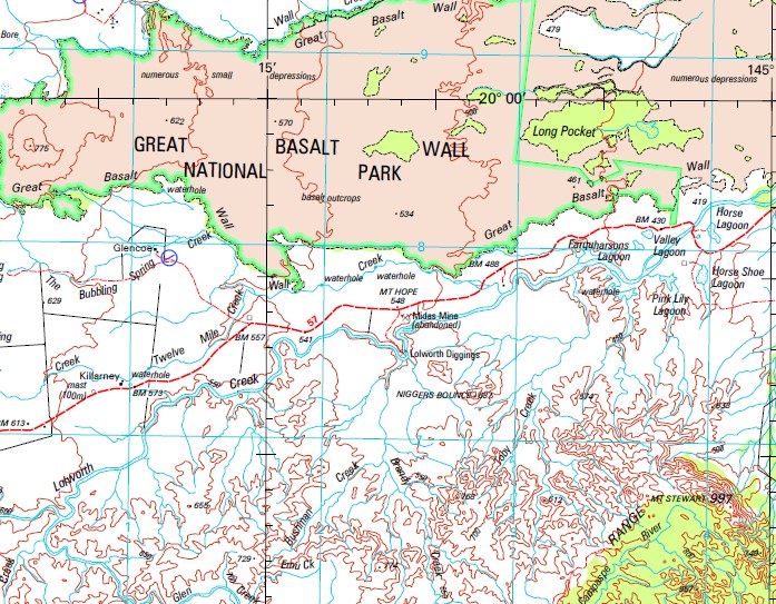
Hughenden 1-250,000 Topographic Map
$15.95 – $30.95
Description:
Print on Demand
Capeville Peronne Spring Fern Kiora Stonington Brookdale Denbigh Uralla Cargoon Camden Park Low Holm Lolworth Strathtay Mount Pleasant Goldsborough Boonderoo Clyde Park Oak Vale Strath-Stewart Cornelia Colindale Ballabay Warwombie Alston Vale Delbessie Lottery Torver Valley Boggleywallah Strathallen Koon Kool Lauderdale New Glendower Blantyre Glentor Downs Mountain View Canterbury Ormonde Rosevale Mount Beckford Strathglass Wattlevale Coolibah Sussex Park Glenmoan Laurel Vale Plains The Strathelen Gunnerside Hughenden Station Monavale Jardine View Penrice Nicoleche Waterloo Hut Ellington Park Renfrew Railview Mount Develin Mortimer Mount Etna Afton Downs Woodbine Hughenden Pentland Afton Mount Agnes Aplin Mount Arthur Bald Hill Ballabay Water Facility Ballindalloch Mount Banks Baronta Basalt Basalt Waterhole Bedford Betts Black Gin Creek Black Mountain Black Mountain Creek Black Valley Spring Blanket Spring Blossom Hill Bluebush Spring Boorooman Boston Bottle Tree Waterhole Boundary Creek Mount Bradshaw Brandy Creek Brumby Creek Bubbling Spring Bulgin Creek Bungaree Creek Burra Burraway Burraway Hills Bushman Creek Camden Canterbury Creek Mount Canterbury Cape River Lake Cargoon Mount castor Cattle Creek Chasm Creek Chiltern Chinaman Spring Clean Skin Creek Coolibah Creek Cornelia Creek Mount Courtney Cow Creek Cracknell Mount Cracknell Mount Davenport Davey Creek Dead Horse Creek Deehan Deep Water Creek Mount Desolation Mount Devlin Mount Dick Dillons Knob Dinalbin Dingo Creek Dinner Creek Dinorwick Dividing Siding Douglas Draught Horse Creek Duck Creek Eight Mile Creek Emu Creek Emu Plains Mount Emu Farquharson Lagoon Fat Hen Creek Five Mile Creek Flaggy Creek Flagstone Creek Fossicker Creek Galah Porcupine Creek Glen Creek Glencoe Glendower Glendower Water Facility Golden Mount Gorge Creek Gorge Spring Griffith Grosmont Gum Creek Hackett Mount Hackett Hawthorne Vale Mount Hope Horse Creek Horse Lagoon Horse Shoe Lagoon Hughenden Creek Humpy Creek Mount James Jardine Creek Jardine Valley Joe Creek Justin Kangaroo Springs Karoon Killarney Killarney Creek Killarney Spring Mount King Kobado Korugan Kubba Lea Creek Leonidas Lilian Lily Lagoon Little Mistake Creek Lolworth Range Long Gully Maude Mickey Spring Middle Creek Mistake Creek Mount Mistake Moocha Creek Lake Moocha Morepork Creek Mount Emu Plains Mount Stewart Mount Sturgeon Mouse Hole Creek Mount Mowbray Niggers Bounce North Branch Creek Norwood O’Brien Creek Oak Creek Oakvale Water Facility Oaky Creek Orange Tree Creek Owen Oxley Creek Mount Oxley Paddy Gully Pentland Water Facility Pine Tree Pine Tree Creek Pine Tree Water Facility Pink Lily Lagoon Policeman Waterhole Mount Pollux Poorooga Porcupine Porcupine Gorge National Park Porcupine Water Facility Prairie Prairie Creek Pretty Plains Range Creek Red Gorge Creek Mount Remarkable Mount Richardson Rileys Water Facility Rocky Creek Rocky Hills Running Creek Rush Creek Sandy Creek Saunders Creek Saw Pit Gully Sawpit Creek Scrubby Creek Sentinel Shearers Creek Six Mile Creek Six Mile Gully Skull Creek Smith Gorge Creek Soda Spring Soda Valley Spear Creek Specimen Creek Spotted Gum Creek Spring Creek Spring Lawn Creek Station Creek Store Creek Surprise Spring Tattoo Waterhole Terang The Bubbling Spring Creek The Gum Flat Three Mile Creek Tindo Toby Creek Tolkuru Torrendam Water Facility Torrens Creek Twelve Mile Creek Tyler Creek Upper Cape Valley Lagoon Mount Walker Wall Creek Warang Warreah Warrigal Warrigal Creek Left Branch Weaner Vale Well Creek White Mountain Creek White Mountains Whitecliff Gorge Creek Windmill Creek Wire Creek Wishaw Wongalee Mount Wongalee Woolshed Creek Worwombie Water Facility Woura Wrexham Yankee Dave Creek Eurunga Great Basalt Wall National Park White Mountains National Park White Mountains Resources Reserve Great Dividing Range The Cape Queensland State of Queensland Georges Well Great Basalt Wall Farquesons Lagoon Blanket Plain Bore Bloodwood Bore Mosquito Plains Bore Mount Stewart Well Stony Hill Crystal Spring Catile Creek Mount Emu Plains Number Six Bore Mount James Bore Paddys Gully Mount Bank Diborwick Well Figtree Spring Gypsy Pocket Bore Bullock Paddock Bore Strath Stewart Sandstone Wall Whitecliff Gorge Spring Valley Well Windmill Creek Bore Hungry Bore Denbeigh Bore Tenterfield Wire Waterhole Worwombie The Valley Bore Barrys Bore Torver Valley Bore Fairlight Warrigal Station Boundry Creek Broken Dam Spinifex Bore Emu Creek Bore Boggle Wallah Ormode Bore Prairie Bore Burra Station Crescent Creek Galah Creek Adams Well Dalray Number One Bore Mount Beckford Bore Phils Microwave Tower Laurelvale Fergusons Bore Eurunga Station Big Beckford Bore The Plains Warreah Station Three A Bores Karoon Station Lake Mucha Ballandalloch Ballindallock Jardine Valley Station Railway Bore Tolkuru Station Baronta Station Penrice Number Two Bore Flats Bore Asbrook Bore North East Bore Station Creek Bore Railview Number Two Bore Garden Creek Outstation Iona Bore Mount Erna Watten Hill Bore Woodbine Well Silky Oak Bore Oakley One Mile Bore
| Name: | Hughenden |
| Publisher: | Geoscience Australia (Australian Government) |
| Scale: | 1:250000 |
| Latitude Range: | 20° 0.0′ S – 21° 0.0′ S |
| Longitude Range: | 144° 0.0′ E – 145° 30.0′ E |
| Projection / Datum: | Universal Transverse Mercator, GDA94 |
| Approx Print Size: | 0.44m X 0.67m |
| Publication Date: | 1-Jun-01 |


