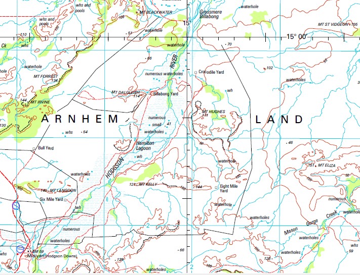
Hodgson Downs 1-250,000 Topographic Map
$15.95 – $30.95
Description:
Print on Demand
Anderson Bore Anderson Creek Angus Spring Arkdip Lagoon Arnold River Bayward Lagoon Bella Glen Creek Bella Glen Yard Billabong Yard Bloodwood Yard Bobby Magee Bore Boundary Bore Boyces Creek Buffalo Hole Buffalo Hole Yard Bull Creek Bull Yard Charley Bore Charley Creek Cork Hole Yard Cow Creek Cow Lagoon Bore Cox River Cox River Landing Ground Crawford Creek Crawford Spring Crocodile Creek Crocodile Yard Daken Harts Lagoon Dalglese Creek Deadmans Creek Dingeri Creek Dollar Yard Don Browns Spring Eight Mile Yard Farrars Bore Flicks Hole Flicks Waterhole Hamilton Lagoon Hodgson Downs Hodgson Downs Health Centre Hodgson River Hodgson River Landing Ground Hodgson River Station Horse Creek Bore Kempsey Creek Kempsey Spring L D Creek L D Yard Lagoon Creek Limmen Longbottom Creek Lubra Springs Mahogany Bore Mahogany Creek Mais Bluff Maryfield Maryfield Creek Mason Bluff Mason Gorge Creek Mc Donald Lagoon Mc Donald Yard McMannis No 2 Bore Mickey Creek Mickey Creek Bore Midway Bore Minimere Lagoon Minyerri Minyerri Aerodrome Minyerri Health Centre Minyerri Police Station Minyerri School Mount Colton Mount Dalgleish Mount Davidson Mount Eliza Mount Forrest Mount Hughes Mount Irvine Mount Kelly Mount Langdon Mount Mueller No 1 Bore No 2 Bore No 3 Bore No 8 Bore Nutwood Downs Nutwood Downs Aerodrome Old Station Yard Packsaddle Yard Paddy Lagoon Paisley Yard Papas Bore Pear Tree Yard Peter Yard Picaninny Yard Pipe Creek Pipe Creek Bore Purdies Bore Purdies Ponds Quewarren Bore Quewarren Spring Red Ochre Creek Red Ochre Yard Revolver Bore Rocky Hole Yard Sand Bore Sandridge Lagoon Sandy Creek Sandy Creek Bore Sandy Lagoon Yard Six Mile Yard Skeleton Bore Snake Creek Snake Hole St Vidgeon Starkvale Bore Station Creek Strangways Bore Sundown Plain Paddock Sundown Plain Yard The Patterson Triangle Bore Watch Creek Watch-A-Bull Bore Dagenhardt Lagoon Campbell Spring Hamiltons Lagoon Baywards Lagoon L.D. Waterhole Mount Landon Paisley Creek L.D. Creek Masons Bluff Makem Lagoon Stag Lagoon Bob Spring Flick Waterhole Bantam Hole Nutwood Downs Station Big Hole Spring Waterhole Minamba Brumby Creek
Part of Arnhem Land
| Name: | Hodgson Downs |
| Publisher: | Geoscience Australia (Australian Government) |
| Scale: | 1:250000 |
| Latitude Range: | 15° 00.0′ S – 16° 0.0′ S |
| Longitude Range: | 133° 30.0′ E – 135° 0.0′ E |
| Projection / Datum: | Universal Transverse Mercator, GDA94 |
| Approx Print Size: | 0.44m X 0.67m |
| Publication Date: | 1-Jun-01 |


