
Gundagai 1-25,000 NSW Topographic Map
$16.95 – $31.95
Description:
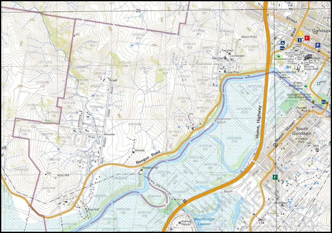
Gundagai 1-25,000 NSW Topographic Map 8527-4-N Print on Demand
Gundagai Asbestos Hill Anzac Park Back Station Creek The Basin Boons Creek Boons Hill Brummys Hill Chinamans Hill Cookoomooroo Creek Darbalara Edwardstown Flowers Hill Gundagai High School Gundagai Post Office Gundagai Public School Gundagai Railway Station Hargraves Gully Jackalass Jones Creek Kangaroo Ground Creek Darbalara Public School Jackalass Creek Jackylass Creek Kangaroo Creek Kangaroo Ground Arm of Blind Creek Mount Kimo Kimo Kimo Basin Kimo Hill Kimovale Long Tunnel Creek Morleys Creek Mount Reno North Gundagai Oak Creek Oak Hill Paddys Rocks Hill Mount Parnassus Reno Sandy Creek Slate Quarry Creek Smiths Hill South Gundagai South Gundagai Public School South Gundagai Railway Station Sprilbry Creek Sprilbry Gully Spring Donald Creek Target Creek Tarrabandra Tarrabandra Public School The Junction Wagara Hill Wagragobilly Willie Ploma Willie Ploma Railway Station Withers Hill Bushmans Daughters Gully Deightons Beach Woodbridge Lagoon Kookoomooroo Creek Jessops Lagoon Mount Parnassus Lookout Balls Platform Tumut River Adjungbilly Creek Balara Big Ben Creek Gundagai South Adelong Creek Snowball Creek The Glen
| Name: | Gundagai |
| Publisher: | New South Wales Government |
| Scale: | 1:25,000 |
| Latitude Range: | 35° 0.0′ S – 35° 7.5′ S |
| Longitude Range: | 148° 0.0′ E – 148° 15.0′ E |
| Datum: | GDA 2020
Edition 2022 |
| Approx Print Size: | 0.56m X 1.11m |
You may also like…
-
Tumorrama 1-25,000 NSW Topographic Map
$16.95 – $31.95Select options This product has multiple variants. The options may be chosen on the product page -
Wondalga 1-25,000 NSW Topographic Map
$16.95 – $31.95Select options This product has multiple variants. The options may be chosen on the product page -
Adjungbilly 1-25,000 NSW Topographic Map
$16.95 – $31.95Select options This product has multiple variants. The options may be chosen on the product page -
Blowering 1-25,000 NSW Topographic Map
$16.95 – $31.95Select options This product has multiple variants. The options may be chosen on the product page -
Tumut 1-25,000 NSW Topographic Map
$16.95 – $31.95Select options This product has multiple variants. The options may be chosen on the product page -
Lacmalac 1-25,000 NSW Topographic Map
$16.95 – $31.95Select options This product has multiple variants. The options may be chosen on the product page