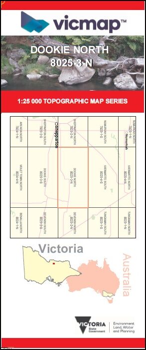

DOOKIE NORTH 1-25,000 Vicmap Topographic Map 8025-3-N
$14.00 – $26.00
Description:
DOOKIE NORTH 1-25,000 Vicmap Topographic Map 80253N Now Print On Demand is used for Walking, 4WD, Fishing, Camping, Motorcycle, both On and Off Road, Gold Prospecting and for those simply going for a family weekend drive.
This is a new series of 1-25,000 scale maps, all of Victoria is now covered by these maps, including maps over the South Australian and NSW Borders.
Topographical maps show not only Contours of the Terrain but Walking Tracks, Sealed and Unsealed Roads, Rivers, Creeks, Lakes, Historical Points of Interest, Old Mine Sites mbtg and National and State Park areas.
Main Features of this map includes:
Covers the old series 1-25,000 Vicmaps Pine Lodge and Mount Major
Dookie, Pine Lodge, Pine Lodge Rail Disused, Marionvale, Mount Major, Channel Station Rail Line, Katandra, Cosgrove, YABBA SOUTH NCR, DOOKIE – KATAMATITE RAIL LINE BR, Yabba South Station Disused
You may also like…
-
DEVENISH NORTH 1-25,000 Vicmap Topographic Map 8025-2-N
$14.00 – $26.00Select options This product has multiple variants. The options may be chosen on the product page -
Devenish 1-50,000 Vicmap
$12.00 – $24.00Select options This product has multiple variants. The options may be chosen on the product page -
DOOKIE SOUTH 1-25,000 Vicmap Topographic Map 8025-3-S
$14.00 – $26.00Select options This product has multiple variants. The options may be chosen on the product page -
DEVENISH SOUTH 1-25,000 Vicmap Topographic Map 8025-2-S
$14.00 – $26.00Select options This product has multiple variants. The options may be chosen on the product page