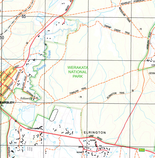
Cessnock 1-25,000 NSW Topographic Map
$16.95 – $31.95
Description:
9132-2-N Print on Demand
Cessnock 1-25,000 Scale NSW Topographical Map is usedfor Walking, 4WD, Fishing, Camping, Motorcycle, both On and Off Road, GoldProspecting and for those simply going for a family weekend drive.
Topographicalmaps show not only Contours of the Terrain but also Walking Tracks, Sealed andUnsealed Roads, Rivers, Creeks, Lakes, Historical Point of Interest, Old MineSites and National and State Park areas.
 Laminate and folded this NSW Topographical map, $12.00 see below
This map includes the following localities: Cessnock Bellbird Kurri Kurri Neath Weston Allandale Aberdare Aberdare Cemetery Village of Abermain Abermain Abermain Post Office Abermain Public School Abermain Railway Station Village of Bellbird Bellbird Creek Bellbird Heights Bellbird Public School Black Waterhole Creek Black Waterholes Creek The Black Waterholes Black Creek Bishops Hill Bishops Creek Bishop Birralee Reserve Booth Park Box Box Hill Bright Mount Bright Lookout Mount Bright Broken Back Range Carmichael Park Cessnock Aerodrome Cessnock East Public School Cessnock High School Cessnock Post Office Cessnock Public School Cessnock Rifle Range Cessnock State Forest Cessnock West Public School Chick Chick Hill Chinamans Hollow Deep Creek Elrington First Creek Fleming Gully Flying Fox Creek Foxy Gully Hebburn Dam Heddon Howe Park Jacksons Hill Kearsley Kearsley Public School Keinbah Caledonia Railway Station Cemetery At Aberdare Cessnock Railway Station Village of Cessnock Fishery Creek Flying Fox Gully George Booth Memorial Park Village of Kearsley Kitchener Kitchener Public School Village of Kitchener Kurri Kurri Cemetery Kurri Kurri High School Kurri Kurri Post Office Kurri Kurri Public School Kurri Kurri Railway Station Limestone Creek London Creek Lovedale Loxford Marrowbone Creek Mary Annes Creek Middle Creek Milfield Millfield Mount View Mount View Park Mount View Range Muggyrang Creek Native Dog Hill Neath Railway Station Village of Neath Nulkaba Nulkaba Public School Village of Nulkaba Oaky Creek Pagans Ground Pelaw Main Pelaw Main Park Pelaw Main Public School Pokolbin Pokolbin Creek Pokolbin Flora Reserve Rothbury Saltwater Creek Sawyers Sawyers Creek Sawyers Gully Second Creek Skinners Hill South Maitland District Cemetery Stanford Stanford Merthyr Stanford Merthyr Public School Stanford Merthyr Railway Station Swamp Creek Teatree Creek Tomalpin Village of Tomalpin Turner Park Varty Park Weston Peace Park Weston Post Office Weston Public School Weston Railway Station Weston Soldiers’ Settlement Burnt Hut Creek Bellbird Miners Memorial Park Campbell Log of Knowledge Park Simm Park Lloyd Park Johns Park Bailey Park Centre Oval South Weston Manning Park O’Neill Park George Winter Park Abernethy Pelton Werakata National Park Abermain Centenary Park Pelaw Main Centenary Park Bluey Frame Park Norm Moyle Park Chappell Park
| Scale: | 1:25000 |
| Latitude Range: | 32 45.0 S – 32 52.5 S |
| Longitude Range: | 151 15.0 E – 151 30.0 E |
| Approx Print Size: | 0.56m X 1.11m |
| Projection: | Transverse Mercator |


