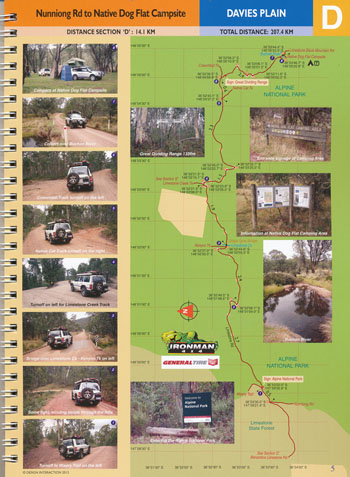
Map Guides include:
- Omeo to Benambra, 22.6km (Section A)
- Banambra to Beloka Road, 15.7km (Section B)
- Beloka Road to Nunniong Road, 17.3km (Section C)
- Nunniong Road to Native Dog Flat Campsite, 14.1km (Section D)
- Limestone Creek Track to The Poplars, 16.0km (Section E)
- McCarthys Track to Mt Misery Trail turnoff, 8.9km (Section F)
- Mt Misery Trail turnoff to Davies Plain Hut, 15.5km (Section G)
- Davies Plain Hut to Tom Groggin Campsite, 18.9km (Section H)
- Tom Groggin Track to Mt Hope Road, 11.4km (Section I)
- Mt Hope Road to Mt Anderson Road, 9.7km (Section J)
- Mt Anderson Road to Mt Gibbo Track, 7.3km (Section K)
- Mt Gibbo Track to Buenba Log Road, 9.4km (Section L)
- Buenba Log Road to Tom Groggin Track turnoff, 12.3km (Section M)
- Tom Groggin Track turnoff to Blue Gum Track, 12.7km (Section N)
- Blue Gum Track to Beloka-Limestone Road Junction, 15.6km (Section O)
- ISBN 9780987412560


